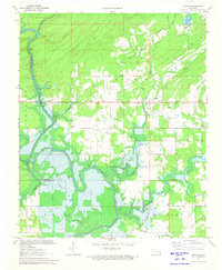
1971 Map of Rattan
USGS Topo · Published 1973About this map
The Kiamichi River winds through the heart of this landscape, its path defining the border between the Kiamichi Hills and the lower floodplains. During this early 1970s survey, the geography was in the midst of a significant transformation as portions of the valley were prepared for inundation by Hugo Lake. This transition is clearly marked by blue hatching in the southern reaches, showing where the river's bends would soon disappear beneath the rising reservoir waters.
Find a feature on this map
30 named features on this map. Tap any name to fly to it.
Don’t see what you’re looking for? This feature index may not catch every label — zoom into the map to look around manually.
Map Details
Editions of this 1971 Rattan Map
2 editions found
Other maps of this area

1901 · Antlers
USGS Topo · 1:125,000

1901 · Alikchi
USGS Topo · 1:125,000

1912 · Antlers
USGS Topo · 1:125,000

1925 · Antlers
USGS Topo · 1:125,000

1950 · Mcalester
USGS Topo · 1:250,000

1961 · Antlers East
USGS Topo · 1:24,000

1962 · McAlester
USGS Topo · 1:250,000

1965 · McAlester
USGS Topo · 1:250,000
1969 · Hugo
USGS Topo · 1:24,000

1971 · Spencerville
USGS Topo · 1:24,000