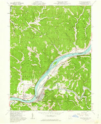
1961 Map of Raven Rock
USGS Topo · Published 1962About this map
St Marys and Newport anchor this riverfront survey, positioned where the Ohio River bends through the borderlands of Washington County, Ohio, and Pleasants County, West Virginia. The landscape is defined by the industrial and transport arteries of the early 1960s, including the Baltimore And Ohio railroad line tracking the river's edge and numerous Gas Wells scattered across the ridgelines like Eddy Ridge and MT Carmel Ridge.
Find a feature on this map
69 named features on this map. Tap any name to fly to it.
Don’t see what you’re looking for? This feature index may not catch every label — zoom into the map to look around manually.
Map Details
Editions of this 1961 Raven Rock Map
4 editions found
Other maps of this area

1903 · Macksburg
USGS Topo · 1:62,500

1904 · Marietta
USGS Topo · 1:62,500

1905 · New Matamoras
USGS Topo · 1:62,500

1905 · Macksburg
USGS Topo · 1:62,500

1906 · Saint Marys
USGS Topo · 1:62,500

1924 · St Marys
USGS Topo · 1:62,500

1924 · New Matamoras
USGS Topo · 1:62,500

1924 · Marietta
USGS Topo · 1:62,500

1926 · New Matamoras
USGS Topo · 1:62,500

1927 · Marietta
USGS Topo · 1:62,500