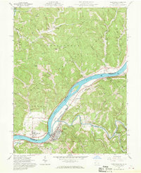
1961 Map of Raven Rock
USGS Topo · Published 1970About this map
The Ohio River dominates this mid-century survey, dividing the riverside communities of Newport and St Marys. As the river winds around Grape Island and Willow Island, it serves as the central artery for the Baltimore and Ohio railroad and the various settlements along its banks. The landscape transitions from the river valley into the timbered slopes of the Wayne National Forest, where high ridges like Eddy Ridge and Independence Ridge define the topography. Gas production is evident throughout the northern hills, with numerous Gas Wells and Gas Wells scattered along Archers Fork and Cady Run. Local history is preserved in the placement of family and community landmarks, from Independence Chapel and the Bowersock Cem to the industrial site of Union Mills tucked along McKim Creek.
Find a feature on this map
68 named features on this map. Tap any name to fly to it.
Don’t see what you’re looking for? This feature index may not catch every label — zoom into the map to look around manually.
Map Details
Editions of this 1961 Raven Rock Map
4 editions found
Other maps of this area

1903 · Macksburg
USGS Topo · 1:62,500

1904 · Marietta
USGS Topo · 1:62,500

1905 · New Matamoras
USGS Topo · 1:62,500

1905 · Macksburg
USGS Topo · 1:62,500

1906 · Saint Marys
USGS Topo · 1:62,500

1924 · St Marys
USGS Topo · 1:62,500

1924 · New Matamoras
USGS Topo · 1:62,500

1924 · Marietta
USGS Topo · 1:62,500

1926 · New Matamoras
USGS Topo · 1:62,500

1927 · Marietta
USGS Topo · 1:62,500