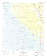
1954 Map of Red Level
USGS Topo · Published 1964About this map
The coastal marshlands of Red Level and the intricate labyrinth of the Crystal River estuary are meticulously detailed in this mid-century survey. Along the eastern edge, the settlement of Red Level sits near 19 and 98, centered around the Red Level Cem and Mt Olive Ch. Evidence of local industry and ancient habitation appears side-by-side, with active Mines situated just north of archaeological features like the Shell Mounds and an Indian Mound near the riverbanks.
Find a feature on this map
61 named features on this map. Tap any name to fly to it.
Don’t see what you’re looking for? This feature index may not catch every label — zoom into the map to look around manually.
Map Details
Editions of this 1954 Red Level Map
5 editions found
Other maps of this area

1954 · Homosassa
USGS Topo · 1:24,000

1954 · Crystal River
USGS Topo · 1:24,000

1954 · Red Level
USGS Topo · 1:24,000

1954 · Yankeetown SE
USGS Topo · 1:24,000

1954 · Ozello
USGS Topo · 1:24,000

1954 · Gainesville
USGS Topo · 1:250,000

1955 · Withlacoochee Bay
USGS Topo · 1:24,000

1955 · Yankeetown
USGS Topo · 1:24,000

1955 · Plant City
USGS Topo · 1:250,000

1958 · Plant City
USGS Topo · 1:250,000