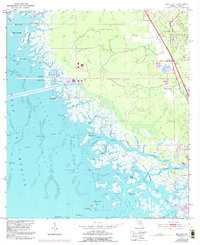
1954 Map of Red Level
USGS Topo · Published 1993About this map
Red Level stands as the primary settlement on this coastal Florida landscape, situated near the intersection of Highway 19 and Highway 98. The map reveals a transition from inland industrial activity, including several Mines and a prominent Powerplant with its associated conveyor, to the intricate wetlands of the St Martins Marsh Aquatic Preserve. History is visible in the physical landscape through the presence of Indian Mounds and Shell Mounds located near the banks of the Crystal River and Salt River. To the north, the massive Cross Florida Barge Canal cuts a straight path toward the Gulf of Mexico, contrasting with the winding natural reaches of Bennetts Creek and Johns Creek. Local genealogy and community life are anchored by the Mt Olive Ch and Red Level Cem situated along the highway corridor.
Find a feature on this map
69 named features on this map. Tap any name to fly to it.
Don’t see what you’re looking for? This feature index may not catch every label — zoom into the map to look around manually.
Map Details
Editions of this 1954 Red Level Map
5 editions found
Other maps of this area

1954 · Homosassa
USGS Topo · 1:24,000

1954 · Crystal River
USGS Topo · 1:24,000

1954 · Red Level
USGS Topo · 1:24,000

1954 · Yankeetown SE
USGS Topo · 1:24,000

1954 · Ozello
USGS Topo · 1:24,000

1954 · Gainesville
USGS Topo · 1:250,000

1955 · Withlacoochee Bay
USGS Topo · 1:24,000

1955 · Yankeetown
USGS Topo · 1:24,000

1955 · Plant City
USGS Topo · 1:250,000

1958 · Plant City
USGS Topo · 1:250,000