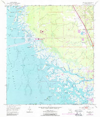
1954 Map of Red Level
USGS Topo · Published 1988About this map
The coastal marshlands and industrial infrastructure of Citrus County define this 1954 landscape, updated with 1980s aerial data. The community of Red Level is the primary settlement, supported by the Mt Olive Ch and Red Level Cem. This area is shaped by significant engineering projects, most notably the Cross Florida Barge Canal and a large Power Plant served by a dedicated Conveyor.
Find a feature on this map
61 named features on this map. Tap any name to fly to it.
Don’t see what you’re looking for? This feature index may not catch every label — zoom into the map to look around manually.
Map Details
Editions of this 1954 Red Level Map
5 editions found
Other maps of this area

1954 · Homosassa
USGS Topo · 1:24,000

1954 · Crystal River
USGS Topo · 1:24,000

1954 · Red Level
USGS Topo · 1:24,000

1954 · Yankeetown SE
USGS Topo · 1:24,000

1954 · Ozello
USGS Topo · 1:24,000

1954 · Gainesville
USGS Topo · 1:250,000

1955 · Withlacoochee Bay
USGS Topo · 1:24,000

1955 · Yankeetown
USGS Topo · 1:24,000

1955 · Plant City
USGS Topo · 1:250,000

1958 · Plant City
USGS Topo · 1:250,000