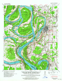
1939 Map of Refuge
USGS Topo · Published 1964About this map
The Mississippi River creates a labyrinth of oxbows and cut-offs along the border of Arkansas and Mississippi, defining a landscape of complex hydraulic engineering in the late 1930s. Centered on the growing city of Greenville, the map shows a period of intense river management following the 1935 Tarpley Cut-Off and the 1933 Leland Cut-Off, which dramatically straightened the main channel and left behind remnants like Bachelor Bend and Walker Bend.
Find a feature on this map
54 named features on this map. Tap any name to fly to it.
Don’t see what you’re looking for? This feature index may not catch every label — zoom into the map to look around manually.
Map Details
Editions of this 1939 Refuge Map
4 editions found
Other maps of this area

1933 · Lamont
USGS Topo · 1:62,500

1936 · McGehee
USGS Topo · 1:62,500

1936 · Eudora
USGS Topo · 1:62,500

1936 · Lake Village
USGS Topo · 1:62,500

1937 · McGehee
USGS Topo · 1:62,500

1939 · Readland
USGS Topo · 1:62,500

1939 · Refuge
USGS Topo · 1:62,500

1939 · Lamont
USGS Topo · 1:62,500

1939 · Tralake
USGS Topo · 1:62,500

1939 · Choctaw
USGS Topo · 1:62,500