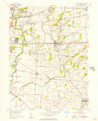
1955 Map of Reynoldsburg
USGS Topo · Published 1956About this map
Columbus and its eastern suburbs are captured here during a period of mid-century expansion, where the city's residential growth meets the agricultural landscape of Jefferson and Truro townships. The Pennsylvania and Baltimore and Ohio railroad corridor serves as a major industrial spine, passing the Claycraft brickworks and Taylor Sta. Significant local landmarks are prominent, including the sprawling Columbus Country Club and the St Theresa Shrine.
Find a feature on this map
67 named features on this map. Tap any name to fly to it.
Don’t see what you’re looking for? This feature index may not catch every label — zoom into the map to look around manually.
Map Details
Editions of this 1955 Reynoldsburg Map
This is the sole edition of this map. No revisions or reprints were ever made.
Other maps of this area

1902 · Westerville
USGS Topo · 1:62,500

1904 · Westerville
USGS Topo · 1:62,500

1907 · Thurston
USGS Topo · 1:62,500

1908 · Granville
USGS Topo · 1:62,500

1909 · Thurston
USGS Topo · 1:62,500

1910 · Granville
USGS Topo · 1:62,500

1925 · East Columbus
USGS Topo · 1:62,500

1943 · East Columbus
USGS Topo · 1:62,500

1947 · Columbus
USGS Topo · 1:250,000

1950 · Marion
USGS Topo · 1:250,000