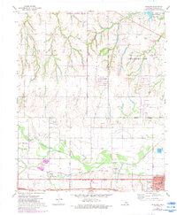
1972 Map of Richland
USGS Topo · Published 1983About this map
The North Canadian River winds through this central Oklahoma landscape, defining the topography south of the St Louis and San Francisco Railroad. The mapping captures a period of suburban expansion as Oklahoma City and Yukon corporate boundaries begin to converge near established rural communities like Richland and Banner. The transition from agrarian roots to modern infrastructure is evident in the presence of a large Feedlot and Sewage Disposal Ponds juxtaposed against historic sites like Frisco Cem and St Johns Sch Cemetery.
Find a feature on this map
42 named features on this map. Tap any name to fly to it.
Don’t see what you’re looking for? This feature index may not catch every label — zoom into the map to look around manually.
Map Details
Editions of this 1972 Richland Map
2 editions found
Other maps of this area

1892 · Kingfisher
USGS Topo · 1:125,000

1893 · Oklahoma City
USGS Topo · 1:62,500

1893 · Minco
USGS Topo · 1:62,500

1895 · Kingfisher
USGS Topo · 1:125,000

1904 · Chickasha
USGS Topo · 1:125,000

1954 · Oklahoma City
USGS Topo · 1:250,000

1956 · Oklahoma City
USGS Topo · 1:62,500

1957 · Oklahoma City
USGS Topo · 1:250,000

1963 · Oklahoma City
USGS Topo · 1:250,000
1966 · Minco NE
USGS Topo · 1:24,000