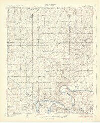
1932 Map of Ripley
USGS Topo · Published 1932About this map
The Cimarron River carves a massive, looping bend through the southern portion of this landscape, creating a dramatic geographic focus for the surrounding farm country. Just north of these waters, the town of Ripley serves as a local hub, while the Atchison Topeka and Santa Fe Railway provides critical transit for the region's agricultural output. This 1920s survey captures a dense network of early rural education and community centers, including Lone Chimney Sch, Rosenwald Sch, and the Ingalls Signet PO.
Find a feature on this map
69 named features on this map. Tap any name to fly to it.
Don’t see what you’re looking for? This feature index may not catch every label — zoom into the map to look around manually.
Map Details
Editions of this 1932 Ripley Map
2 editions found

Other maps of this area

1893 · Stillwater
USGS Topo · 1:62,500

1908 · Agra
USGS Topo · 1:62,500

1909 · Perkins
USGS Topo · 1:62,500

1929 · Yale
USGS Topo · 1:62,500

1929 · Ripley
USGS Topo · 1:62,500

1929 · Skedee
USGS Topo · 1:62,500

1930 · Pawnee
USGS Topo · 1:62,500

1931 · Drumright
USGS Topo · 1:62,500

1931 · Skedee
USGS Topo · 1:62,500

1932 · Yale
USGS Topo · 1:62,500