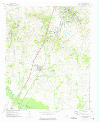
1972 Map of Ripley South
USGS Topo · Published 1974About this map
The southern outskirts of Ripley and the town of Henning anchor this mid-century portrait of Lauderdale County. The Illinois Central Gulf railroad serves as a primary north-south spine, connecting these communities and the smaller settlement at Opossum. Along the southern boundary, the Hatchie River meanders across the border into Tipton County, near the community of Rialto and the Garden of Everlasting Life. The landscape is dotted with rural landmarks essential for genealogical research, including the Bethlehem Cem, Poplar Grove Cem, and Hamlett Temple Cem. Institutional life is well-documented through several schools and churches like Salem Ch and St Mark Ch, while the industrial character of the era is reflected in scattered Gravel Pits and the Sewage Disposal Pond near Henning.
Find a feature on this map
37 named features on this map. Tap any name to fly to it.
Don’t see what you’re looking for? This feature index may not catch every label — zoom into the map to look around manually.
Map Details
Editions of this 1972 Ripley South Map
2 editions found
Other maps of this area

1939 · Hales Point
USGS Topo · 1:62,500

1939 · Halls
USGS Topo · 1:62,500

1952 · Hales Point
USGS Topo · 1:62,500

1952 · Gates
USGS Topo · 1:24,000

1956 · Blytheville
USGS Topo · 1:250,000

1959 · Blytheville
USGS Topo · 1:250,000

1961 · Hales Point
USGS Topo · 1:62,500

1961 · Rialto
USGS Topo · 1:62,500

1961 · Halls
USGS Topo · 1:62,500

1962 · Rialto
USGS Topo · 1:62,500