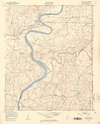
1947 Map of Riverside
USGS Topo · Published 1953About this map
The Coosa River defines the western border of Talladega County in this late 1940s survey, winding past the settlements of Riverside and Seddon. The landscape is deeply influenced by the river’s hydrological and industrial importance, marked clearly by the presence of Lock No 5 (Abandoned) and the confluence with Choccolocco Creek. The Southern railroad line parallels the river through the northern reaches of the quadrangle, facilitating the movement of goods between these small riverside communities and the larger town of Lincoln.
Find a feature on this map
30 named features on this map. Tap any name to fly to it.
Don’t see what you’re looking for? This feature index may not catch every label — zoom into the map to look around manually.
Map Details
Editions of this 1947 Riverside Map
4 editions found
Other maps of this area

1889 · Springville
USGS Topo · 1:125,000

1890 · Talladega
USGS Topo · 1:125,000

1892 · Springville
USGS Topo · 1:125,000

1892 · Talladega
USGS Topo · 1:125,000

1943 · Talladega
USGS Topo · 1:62,500

1946 · Talladega
USGS Topo · 1:62,500

1947 · Eastaboga
USGS Topo · 1:24,000

1947 · Ragland
USGS Topo · 1:62,500

1947 · Ragland
USGS Topo · 1:24,000

1947 · Riverside
USGS Topo · 1:24,000