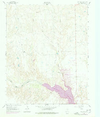
1962 Map of Roach Ranch
USGS Topo · Published 1978About this map
Roach Ranch and the developing community of Howardwick anchor this West Texas landscape during a period of significant hydrologic transformation. The 1960s and 70s saw the creation of the Greenbelt Reservoir, which inundated portions of the valley where the Salt Fork Red River flows. The mapping reflects this change with purple revision overlays indicating the expanded shoreline and new recreation-focused features such as the Clarendon Country Club and an associated Golf Course.
Find a feature on this map
15 named features on this map. Tap any name to fly to it.
Don’t see what you’re looking for? This feature index may not catch every label — zoom into the map to look around manually.
Map Details
Editions of this 1962 Roach Ranch Map
3 editions found
Other maps of this area

1954 · Amarillo
USGS Topo · 1:250,000

1954 · Plainview
USGS Topo · 1:250,000

1958 · Amarillo
USGS Topo · 1:250,000

1958 · Plainview
USGS Topo · 1:250,000

1960 · Groom
USGS Topo · 1:62,500

1962 · Lelia Lake
USGS Topo · 1:24,000

1962 · Roach Ranch
USGS Topo · 1:24,000

1962 · Griffin Ranch
USGS Topo · 1:24,000

1963 · Clarendon
USGS Topo · 1:24,000

1963 · Buffalo Arroyo
USGS Topo · 1:24,000