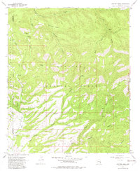
1967 Map of Robinson Mesa
USGS Topo · Published 1982About this map
Apache National Forest dominates this mid-1960s terrain, where the high ground of Robinson Mesa is deeply dissected by a network of drainage canyons. The map documents a landscape primarily defined by water access and remote ranching operations, such as Four Drag Ranch and 7 Cross A Ranch. The small settlement at Honeymoon serves as a focal point near the northern edge, situated along the upper reaches of Eagle Creek.
Find a feature on this map
28 named features on this map. Tap any name to fly to it.
Don’t see what you’re looking for? This feature index may not catch every label — zoom into the map to look around manually.
Map Details
Editions of this 1967 Robinson Mesa Map
3 editions found
Other maps of this area

1913 · Morenci
USGS Topo · 1:125,000

1915 · Morenci
USGS Topo · 1:125,000

1922 · Nutrioso
USGS Topo · 1:125,000

1954 · Clifton
USGS Topo · 1:250,000

1957 · Clifton
USGS Topo · 1:250,000

1958 · Clifton
USGS Topo · 1:250,000

1958 · Hannagan Meadow
USGS Topo · 1:62,500

1962 · Clifton
USGS Topo · 1:250,000

1967 · Freezeout Mountain
USGS Topo · 1:24,000

1967 · Robinson Mesa
USGS Topo · 1:24,000