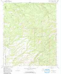
1967 Map of Robinson Mesa
USGS Topo · Published 1991About this map
Apache National Forest dominates this landscape along the border of Graham and Greenlee counties, where deep drainages like Hot Air Canyon and Bear Canyon carve through the high ground of Robinson Mesa. The settlement at Honeymoon and the nearby Honeymoon Campground serve as central points for the area's limited road network, which transitions into rugged tracks like the Bear Hogtrail and various pack trails.
Find a feature on this map
31 named features on this map. Tap any name to fly to it.
Don’t see what you’re looking for? This feature index may not catch every label — zoom into the map to look around manually.
Map Details
Editions of this 1967 Robinson Mesa Map
3 editions found
Other maps of this area

1913 · Morenci
USGS Topo · 1:125,000

1915 · Morenci
USGS Topo · 1:125,000

1922 · Nutrioso
USGS Topo · 1:125,000

1954 · Clifton
USGS Topo · 1:250,000

1957 · Clifton
USGS Topo · 1:250,000

1958 · Clifton
USGS Topo · 1:250,000

1958 · Hannagan Meadow
USGS Topo · 1:62,500

1962 · Clifton
USGS Topo · 1:250,000

1967 · Freezeout Mountain
USGS Topo · 1:24,000

1967 · Robinson Mesa
USGS Topo · 1:24,000