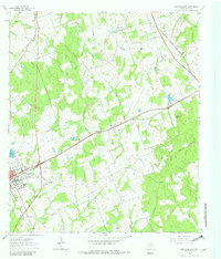
1961 Map of Rockdale East
USGS Topo · Published 1982About this map
Industrial and rural landscapes intersect at Rockdale, where the Missouri Pacific rail line and several prominent mines define the local economy during the early 1960s. The town's expansion is evident in the dense street grid and the presence of the Rockdale Airfield to the south. Beyond the residential center, the map reveals a deeply rooted community landscape marked by numerous historical burial grounds, including Oaklawn Cem, San Jose Cem, and the San Antonio Cem.
Find a feature on this map
30 named features on this map. Tap any name to fly to it.
Don’t see what you’re looking for? This feature index may not catch every label — zoom into the map to look around manually.
Map Details
Editions of this 1961 Rockdale East Map
3 editions found
Other maps of this area

1885 · Taylor
USGS Topo · 1:125,000

1887 · Taylor
USGS Topo · 1:125,000

1894 · Taylor
USGS Topo · 1:125,000

1954 · Austin
USGS Topo · 1:250,000

1956 · Milano
USGS Topo · 1:62,500

1961 · Hanover
USGS Topo · 1:24,000

1961 · Cameron
USGS Topo · 1:24,000

1961 · Rockdale East
USGS Topo · 1:24,000

1962 · Rockdale West
USGS Topo · 1:24,000
1962 · Pettibone
USGS Topo · 1:24,000