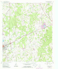
1961 Map of Rockdale East
USGS Topo · Published 1989About this map
The eastern outskirts of Rockdale are defined by a landscape transitioning between early twentieth-century rail infrastructure and mid-century industrial growth. This area, documented in 1961 with later revisions, shows the Southern Pacific and Missouri Pacific railroads converging, reflecting the town's importance as a regional transportation hub. Local history is deeply etched into the land through a series of family and community burial grounds, including Oaklawn Cem, Aycock Cem, and the San Jose Cem, alongside rural landmarks like Mt Zion Ch.
Find a feature on this map
35 named features on this map. Tap any name to fly to it.
Don’t see what you’re looking for? This feature index may not catch every label — zoom into the map to look around manually.
Map Details
Editions of this 1961 Rockdale East Map
3 editions found
Other maps of this area

1885 · Taylor
USGS Topo · 1:125,000

1887 · Taylor
USGS Topo · 1:125,000

1894 · Taylor
USGS Topo · 1:125,000

1954 · Austin
USGS Topo · 1:250,000

1956 · Milano
USGS Topo · 1:62,500

1961 · Hanover
USGS Topo · 1:24,000

1961 · Cameron
USGS Topo · 1:24,000

1961 · Rockdale East
USGS Topo · 1:24,000

1962 · Rockdale West
USGS Topo · 1:24,000
1962 · Pettibone
USGS Topo · 1:24,000