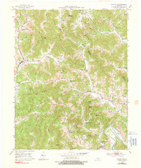
1952 Map of Rockholds
USGS Topo · Published 1991About this map
Rockholds and the surrounding Whitley County landscape are defined by a complex network of narrow valleys and high ridges in the early 1950s. The Louisville and Nashville railroad corridor follows Carr Creek, providing a vital transit link through the difficult terrain of King Mountain and Bald Knob. This era shows a community deeply rooted in its local geography, evidenced by the numerous small family cemeteries like McNeil Cem and Perkins Cem, and a proliferation of rural schoolhouses such as Brummett Sch and Wells Sch. In the higher elevations, Strip Mines indicate the active resource extraction occurring alongside traditional mountain life. The southern portion of the sheet is anchored by the Cumberland River near Louden, where the topography softens slightly as several creek systems, including Whetstone Creek and Meadow Creek, converge toward the river valley.
Find a feature on this map
63 named features on this map. Tap any name to fly to it.
Don’t see what you’re looking for? This feature index may not catch every label — zoom into the map to look around manually.
Map Details
Editions of this 1952 Rockholds Map
4 editions found

Other maps of this area

1886 · Cumberland Gap
USGS Topo · 1:125,000

1888 · Cumberland Gap
USGS Topo · 1:125,000

1890 · Williamsburg
USGS Topo · 1:125,000

1891 · Cumberland Gap
USGS Topo · 1:125,000

1894 · Williamsburg
USGS Topo · 1:125,000

1952 · Corbin
USGS Topo · 1:24,000

1952 · Wofford
USGS Topo · 1:24,000

1952 · Barbourville
USGS Topo · 1:24,000

1952 · Heidrick
USGS Topo · 1:24,000

1952 · Vox
USGS Topo · 1:24,000