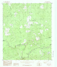
1984 Map of Rockland
USGS Topo · Published 1984About this map
The Angelina National Forest dominates this East Texas landscape, where the Neches River carves a winding course through the timberlands of the Piney Woods. This mid-1980s provisional survey highlights the intricate drainage network feeding into the river, including Shawnee Creek, Turpentine Creek, and Graham Creek. The settlement of Rockland sits near the riverbanks, anchored by the confluence of Sulphur Branch and Greenwood Branch.
Find a feature on this map
28 named features on this map. Tap any name to fly to it.
Don’t see what you’re looking for? This feature index may not catch every label — zoom into the map to look around manually.
Map Details
Editions of this 1984 Rockland Map
This is the sole edition of this map. No revisions or reprints were ever made.
Other maps of this area

1928 · Zavalla 3-c
USGS Topo · 1:24,000

1928 · Lufkin 4-d
USGS Topo · 1:24,000

1931 · Zavalla
USGS Topo · 1:62,500

1932 · Manning
USGS Topo · 1:62,500

1953 · Palestine
USGS Topo · 1:250,000

1954 · Beaumont
USGS Topo · 1:250,000

1955 · Woodville
USGS Topo · 1:62,500

1955 · Camden
USGS Topo · 1:62,500

1957 · Beaumont
USGS Topo · 1:250,000

1957 · Palestine
USGS Topo · 1:250,000