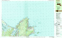
1984 Map of Rockport
USGS Topo · Published 1984About this map
Cape Ann's rocky perimeter and seafaring heritage are documented in this mid-1980s coastal study, which highlights the dense concentration of maritime and inland landmarks around Rockport. The coastline is defined by granite points and coves like Bearskin Neck and Pigeon Cove, where the landscape is peppered with numerous quarries that historically fueled the local economy. On the eastern tip, Thacher Island and Milk Island sit offshore, while the Annisquam Lighthouse guards the entrance to Ipswich Bay.
Find a feature on this map
72 named features on this map. Tap any name to fly to it.
Don’t see what you’re looking for? This feature index may not catch every label — zoom into the map to look around manually.
Map Details
Editions of this 1984 Rockport Map
2 editions found
Other maps of this area

1886 · Gloucester
USGS Topo · 1:62,500

1888 · Newburyport
USGS Topo · 1:62,500

1888 · Gloucester
USGS Topo · 1:62,500

1888 · Salem
USGS Topo · 1:62,500

1890 · Newburyport
USGS Topo · 1:62,500

1893 · Salem
USGS Topo · 1:62,500

1893 · Gloucester
USGS Topo · 1:62,500

1894 · Newburyport
USGS Topo · 1:62,500

1917 · Salem
USGS Topo · 1:62,500

1918 · Gloucester
USGS Topo · 1:62,500