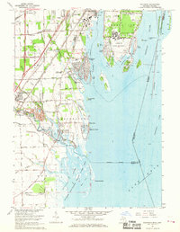
1967 Map of Rockwood
USGS Topo · Published 1969About this map
The Detroit River and its complex archipelago dominate this late 1960s survey, revealing a landscape defined by maritime industry and military presence. On the southern tip of Grosse Ile, the Grosse Ile Naval Air Station occupies a significant footprint alongside the Grosse Ile Country Club, while the surrounding waters are marked by shipping channels like the Livingstone Channel and the Amherstburg Channel. This era shows the dense network of islands including Celeron Island, Hickory Island, and Sugar Island before further modern shoreline modifications.
Find a feature on this map
82 named features on this map. Tap any name to fly to it.
Don’t see what you’re looking for? This feature index may not catch every label — zoom into the map to look around manually.
Map Details
Editions of this 1967 Rockwood Map
3 editions found
Other maps of this area

1906 · Wyandotte
USGS Topo · 1:62,500

1906 · Romulus
USGS Topo · 1:62,500

1912 · Wyandotte
USGS Topo · 1:62,500

1912 · Monroe
USGS Topo · 1:62,500

1914 · Monroe
USGS Topo · 1:62,500

1928 · Romulus
USGS Topo · 1:62,500

1929 · Wyandotte
USGS Topo · 1:62,500

1936 · Wyandotte
USGS Topo · 1:31,680

1936 · Rockwood
USGS Topo · 1:31,680

1936 · Stony Point
USGS Topo · 1:31,680