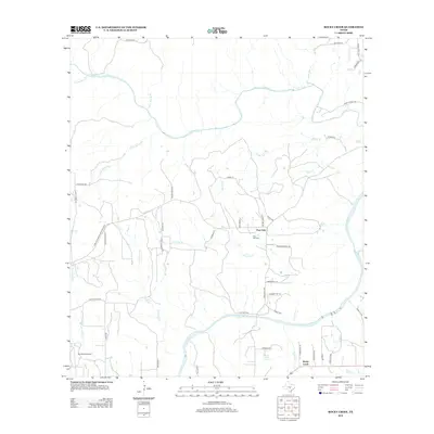
2012 Map of Rocky Creek
USGS Topo · Published 2012About this map
The Pedernales River carves through the Texas Hill Country in this 2012 survey, where the landscape is defined by its intricate network of springs and limestone-bed creeks. In the center of the sheet, the settlement of Post Oak sits near the Post Oak Cem, surrounded by named watercourses like Post Oak Cr and Walker Br. This area shows a typical Central Texas ranching pattern, with family-named roads such as Yentzen Ranch Rd, Jones Scheuer Rd, and Lindig Ln providing access to private holdings. To the southwest, the LBJ Ranch Airport and the eponymous settlement of Rocky Creek reflect the local history and geography of Blanco County. Further north, N Grape Cr and its tributaries, including Dry Hollow Cr and Basin Spring Br, illustrate the drainage patterns that have shaped these uplands for generations.
Find a feature on this map
50 named features on this map. Tap any name to fly to it.
Don’t see what you’re looking for? This feature index may not catch every label — zoom into the map to look around manually.
Map Details
Editions of this 2012 Rocky Creek Map
This is the sole edition of this map. No revisions or reprints were ever made.
Other maps of this area

1887 · Blanco
USGS Topo · 1:125,000

1894 · Fredericksburg
USGS Topo · 1:125,000

1894 · Blanco
USGS Topo · 1:125,000

1954 · Llano
USGS Topo · 1:250,000

1955 · Llano
USGS Topo · 1:250,000

1956 · Llano
USGS Topo · 1:250,000

1961 · Stonewall
USGS Topo · 1:24,000

1961 · Hye
USGS Topo · 1:24,000

1961 · Cave Creek School
USGS Topo · 1:24,000

1961 · Rocky Creek
USGS Topo · 1:24,000