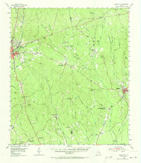
1955 Map of Roganville
USGS Topo · Published 1973About this map
Deep pine forests and scattered rural communities define this mid-century look at the border between Jasper and Newton counties. The landscape is interconnected by the Gulf Colorado and Santa Fe Railroad and the Missouri Pacific Railroad, serving timber-adjacent settlements like Roganville and Holly Springs. Local life centers on numerous small congregations such as Pleasant Hill Ch and Farrs Chapel, alongside civic landmarks like Steers Stadium and the East Texas Baptist Encampment. Evidence of shifting populations appears in several rural education sites, including the Clare Creek Sch (ABAND) and Temple Springs Sch. Extensive water networks like Big Cow Creek and Thickety Creek drain the terrain, providing the natural framework for the family-named cemeteries and homesteads that populate these woods.
Find a feature on this map
69 named features on this map. Tap any name to fly to it.
Don’t see what you’re looking for? This feature index may not catch every label — zoom into the map to look around manually.
Map Details
Editions of this 1955 Roganville Map
2 editions found

Other maps of this area

1935 · Wilson Lake
USGS Topo · 1:31,680

1944 · Wiergate
USGS Topo · 1:62,500

1947 · Wilson Lake
USGS Topo · 1:31,680

1948 · Wiergate
USGS Topo · 1:62,500

1952 · Lake Charles
USGS Topo · 1:250,000

1953 · Alexandria
USGS Topo · 1:250,000

1953 · Palestine
USGS Topo · 1:250,000

1954 · Wiergate
USGS Topo · 1:24,000

1954 · Wiergate
USGS Topo · 1:62,500

1954 · Lake Charles
USGS Topo · 1:250,000