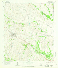
1964 Map of Rogers
USGS Topo · Published 1965About this map
Rogers serves as the primary hub in this central Texas landscape, situated along the tracks of the Gulf Colorado and Santa Fe railroad. The topography is defined by the branching drainages of Big Elm Creek and South Elm Creek, which create a series of low ridges and valleys that dictate the placement of small rural communities like New Colony and Edgewood. An Indefinite Boundary marks the division between Bell and Milam counties, cutting across the agricultural terrain. For those tracing family histories in the area, the map preserves the locations of the Rogers Cem and McCann Cem, alongside rural landmarks such as a prominent Water Tank and Athletic Field near the town center. The presence of Rogers Lake and several dry hollows, including Dry Hollow, illustrates the drainage patterns vital to the region's ranching and farming operations during the mid-1960s.
Find a feature on this map
24 named features on this map. Tap any name to fly to it.
Don’t see what you’re looking for? This feature index may not catch every label — zoom into the map to look around manually.
Map Details
Editions of this 1964 Rogers Map
2 editions found
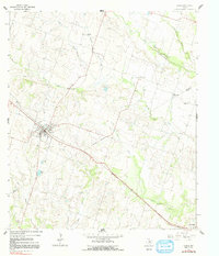
Other maps of this area

1885 · Taylor
USGS Topo · 1:125,000

1887 · Taylor
USGS Topo · 1:125,000

1892 · Temple
USGS Topo · 1:125,000

1894 · Taylor
USGS Topo · 1:125,000

1910 · Buckholts
USGS Topo · 1:24,000

1912 · Buckholts
USGS Topo · 1:31,680

1931 · Belton
USGS Topo · 1:62,500

1954 · Waco
USGS Topo · 1:250,000

1954 · Austin
USGS Topo · 1:250,000

1955 · Waco
USGS Topo · 1:250,000