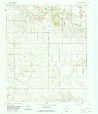
1964 Map of Rolla NE
USGS Topo · Published 1982About this map
The Salt Fork Red River carves a distinctive path across this landscape in Collingsworth County, defining the northern geography with its broad, meandering bed. This area of the Texas Panhandle exhibits a transition in land use, where the rugged drainage of the river contrasts with the more orderly ranching and farming lands to the south. An Old Railroad Grade cuts across the eastern portion of the terrain, serving as a silent indicator of former transportation networks that once connected this corner of Texas to wider markets.
Find a feature on this map
6 named features on this map. Tap any name to fly to it.
Don’t see what you’re looking for? This feature index may not catch every label — zoom into the map to look around manually.
Map Details
Editions of this 1964 Rolla NE Map
2 editions found
Other maps of this area

1954 · Amarillo
USGS Topo · 1:250,000

1954 · Plainview
USGS Topo · 1:250,000

1958 · Amarillo
USGS Topo · 1:250,000

1958 · Plainview
USGS Topo · 1:250,000

1959 · Wellington NW
USGS Topo · 1:24,000

1964 · Rolla SW
USGS Topo · 1:24,000

1964 · Rolla NE
USGS Topo · 1:24,000

1964 · Wellington
USGS Topo · 1:24,000

1964 · Quail
USGS Topo · 1:24,000
1964 · Abra
USGS Topo · 1:24,000