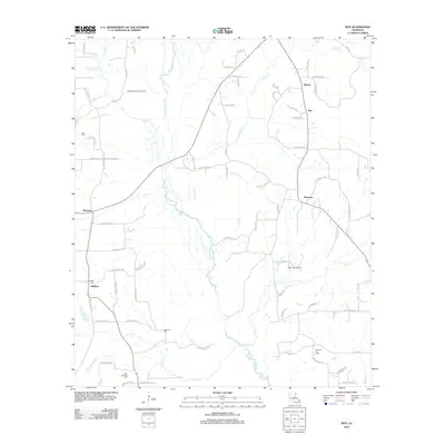
2012 Map of Roy
USGS Topo · Published 2012About this map
Black Lake Bayou and its numerous tributaries, including Church Br and Stanley Cr, define the drainage patterns of this rural landscape in Red River Parish. Small agricultural and resource-based communities like Alberta, Roy, and Ebenezer are connected by a network of parish roads. Local history is anchored by family and community burial sites such as Bethel Cem near Methvin and Luke Cem to the northwest. The industrial footprint of the region is evident in the active extraction sites, notably the Madden Branch Gas Field and the Topy Creek Oil Field, which punctuate the woodlands and fields. This survey provides a clear look at the parish road system, including named routes like Punkin Center Rd and Harper Valley Rd, that link these remote settlements.
Find a feature on this map
85 named features on this map. Tap any name to fly to it.
Don’t see what you’re looking for? This feature index may not catch every label — zoom into the map to look around manually.
Map Details
Editions of this 2012 Roy Map
This is the sole edition of this map. No revisions or reprints were ever made.
Other maps of this area

1947 · Ringgold
USGS Topo · 1:62,500

1947 · Ashland
USGS Topo · 1:62,500

1948 · Coushatta
USGS Topo · 1:62,500

1948 · Jamestown
USGS Topo · 1:62,500

1949 · Jamestown
USGS Topo · 1:62,500

1955 · Shreveport
USGS Topo · 1:250,000

1956 · Shreveport
USGS Topo · 1:250,000

1956 · Ringgold
USGS Topo · 1:62,500
1957 · Coushatta
USGS Topo · 1:62,500

1957 · Ashland
USGS Topo · 1:62,500