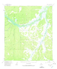
1952 Map of Ruby A-5
USGS Topo · Published 1975About this map
Sulatna Crossing stands at a pivotal point where the Winter Trail meets the winding Sulatna River. This 1952 study, based on aerial photography, details a landscape shaped by early interior Alaska resource extraction, evidenced by the Strip Mine and the nearby Schist Creek operations. The presence of an Aband Ditch near Fourth of July Creek suggests an era of hydraulic mining or water diversion that had already passed its peak by the time of the survey.
Find a feature on this map
35 named features on this map. Tap any name to fly to it.
Don’t see what you’re looking for? This feature index may not catch every label — zoom into the map to look around manually.
Map Details
Editions of this 1952 Ruby A-5 Map
3 editions found
Other maps of this area

1950 · Medfra
USGS Topo · 1:250,000

1951 · Ruby
USGS Topo · 1:250,000

1952 · Ruby A-4
USGS Topo · 1:63,360

1952 · Ruby B-6
USGS Topo · 1:63,360

1952 · Ruby B-4
USGS Topo · 1:63,360

1952 · Ruby B-5
USGS Topo · 1:63,360

1952 · Ruby A-5
USGS Topo · 1:63,360

1952 · Ruby A-6
USGS Topo · 1:63,360

1952 · Ruby
USGS Topo · 1:250,000

1954 · Medfra D-5
USGS Topo · 1:63,360