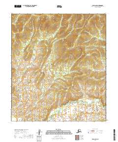
2019 Map of Ruby A-6 SW
USGS Topo · Published 2019About this map
Wilson Cr and Beaver Cr navigate an intricate drainage network in this remote portion of the Yukon-Koyukuk region. The landscape is defined by a series of north-south ridges and deep creek valleys, where waterways like Diamond Cr and Mystery Cr flow between high elevation contours. This particular terrain, marked by the presence of Poorman Cr in the southern reaches, reflects the undeveloped interior of Alaska as documented by the U.S. Geological Survey in 2019. The map provides a detailed view of the township and range system, including t16s r15e and t17s r16e, which organizes this expansive wilderness into a formal grid for land management and mineral interest.
Find a feature on this map
10 named features on this map. Tap any name to fly to it.
Don’t see what you’re looking for? This feature index may not catch every label — zoom into the map to look around manually.
Map Details
Editions of this 2019 Ruby A-6 SW Map
This is the sole edition of this map. No revisions or reprints were ever made.
Other maps of this area

1945 · Nulato
USGS Topo · 1:250,000

1950 · Medfra
USGS Topo · 1:250,000

1951 · Ophir
USGS Topo · 1:250,000

1951 · Nulato
USGS Topo · 1:250,000

1951 · Ruby
USGS Topo · 1:250,000

1952 · Ruby A-6
USGS Topo · 1:63,360
1952 · Nulato A-1
USGS Topo · 1:63,360

1952 · Nulato
USGS Topo · 1:250,000

1952 · Ruby
USGS Topo · 1:250,000

1954 · Medfra D-6
USGS Topo · 1:63,360