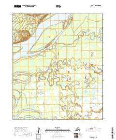
2019 Map of Ruby D-3 NE
USGS Topo · Published 2019About this map
Yukon River waters dominate this landscape of the Yukon-Koyukuk region, carving a complex network of channels and backwaters through the interior. Large landmasses like Kathaleen Island are defined by the split flow of the main river and the lengthy Bering Slough, illustrating the dynamic nature of this fluvial system. The topography is characterized by low-lying wetlands and intricate drainage patterns, with Bering Creek meandering through the eastern sections and the Nowitna River entering from the southwest. Landmark points such as Bering Point provide navigational reference in a territory where the movement of water dictates the geography. This survey documents the specific alignment of bars and secondary channels before natural shifts and seasonal floods alter the course of these northern waterways.
Find a feature on this map
10 named features on this map. Tap any name to fly to it.
Don’t see what you’re looking for? This feature index may not catch every label — zoom into the map to look around manually.
Map Details
Editions of this 2019 Ruby D-3 NE Map
This is the sole edition of this map. No revisions or reprints were ever made.
Other maps of this area

1951 · Ruby
USGS Topo · 1:250,000

1951 · Melozitna
USGS Topo · 1:250,000

1952 · Melozitna A-2
USGS Topo · 1:63,360

1952 · Ruby D-3
USGS Topo · 1:63,360

1952 · Ruby D-2
USGS Topo · 1:63,360

1952 · Ruby
USGS Topo · 1:250,000

1953 · Melozitna A-2
USGS Topo · 1:63,360
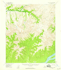
1954 · Melozitna A-3
USGS Topo · 1:63,360

1956 · Melozitna
USGS Topo · 1:250,000

1964 · Ruby
USGS Topo · 1:250,000