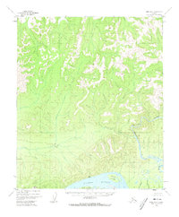
1952 Map of Ruby D-6
USGS Topo · Published 1973About this map
The Yukon River dominates the southern edge of this mid-century landscape, a vital corridor for transportation and subsistence in the Alaska interior. This 1952 study, based on aerial photography, documents the braided river channels and large islands including Big Island and Melozi Island. To the north, the terrain transitions into a complex network of drainages and canyons, most notably where the Melozitna River carves through the land. The presence of a Gaging Sta along the Melozitna and a solitary Cabin near the junction of Lower Nikieumat Cr and Upper Nikieumat Creek indicates the sparse but essential human footprint tied to water monitoring and wilderness travel. Notable tributaries like Bear Creek and Grayling Creek feed into these larger systems, illustrating the hydrography of the Ruby quadrangle before modern development altered its remote character.
Find a feature on this map
12 named features on this map. Tap any name to fly to it.
Don’t see what you’re looking for? This feature index may not catch every label — zoom into the map to look around manually.
Map Details
Editions of this 1952 Ruby D-6 Map
2 editions found
Other maps of this area

1945 · Nulato
USGS Topo · 1:250,000

1951 · Nulato
USGS Topo · 1:250,000

1951 · Ruby
USGS Topo · 1:250,000

1951 · Kateel River
USGS Topo · 1:250,000

1951 · Melozitna
USGS Topo · 1:250,000

1952 · Nulato C-1
USGS Topo · 1:63,360

1952 · Nulato D-1
USGS Topo · 1:63,360

1952 · Ruby D-6
USGS Topo · 1:63,360

1952 · Kateel River A-1
USGS Topo · 1:63,360

1952 · Ruby D-5
USGS Topo · 1:63,360