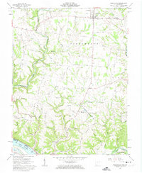
1961 Map of Russellville
USGS Topo · Published 1963About this map
Russellville serves as the primary hub in this portion of Brown County, where the intersection of several historic routes like the Russellville Winchester Road anchors the local commerce. The landscape is defined by the winding course of Straight Creek and Redoak Creek, which carve through the plateau to create prominent landforms like Hillman Ridge and Pisgah Ridge. Southward, the terrain descends toward the Ohio River, where the historic John Rankin Home stands overlooking the water near Ripley.
Find a feature on this map
74 named features on this map. Tap any name to fly to it.
Don’t see what you’re looking for? This feature index may not catch every label — zoom into the map to look around manually.
Map Details
Editions of this 1961 Russellville Map
Other maps of this area

1915 · Maysville
USGS Topo · 1:62,500

1918 · Seaman
USGS Topo · 1:62,500

1919 · Maysville
USGS Topo · 1:62,500

1928 · Higginsport
USGS Topo · 1:48,000

1929 · Springdale
USGS Topo · 1:48,000

1931 · Higginsport
USGS Topo · 1:62,500

1935 · Springdale
USGS Topo · 1:62,500

1952 · Maysville East
USGS Topo · 1:24,000

1952 · Germantown
USGS Topo · 1:24,000

1952 · Higginsport
USGS Topo · 1:24,000