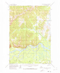
1952 Map of Russian Mission C-3
USGS Topo · Published 1973About this map
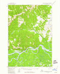
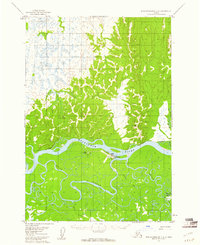
The Portage Mountains dominate the northern terrain of this 1950s interior landscape, giving way to the sweeping curves of the Kuskokwim River. In this era before extensive infrastructure, the river served as the primary corridor for movement, supplemented by a Winter Trail that cuts across the marshy lowlands to the east. The map captures a moment when the Bureau of Land Management was predetermining land lines for unsurveyed areas, reflecting the early administrative efforts to organize this territory following the war. Sparse human presence is marked only by a solitary Cabin situated along the riverbank near a significant bend. To the south, Discovery Creek winds through an expansive network of wetlands and small lakes, illustrating the complex hydrology of the Kuskokwim floodplain where land and water often merge.
Find a feature on this map
7 named features on this map. Tap any name to fly to it.
Don’t see what you’re looking for? This feature index may not catch every label — zoom into the map to look around manually.
Map Details
Editions of this 1952 Russian Mission C-3 Map
3 editions found

Other maps of this area
1947 · Russian Mission
USGS Topo · 1:250,000

1950 · Russian Mission
USGS Topo · 1:250,000
1952 · Russian Mission D-2
USGS Topo · 1:63,360
1952 · Russian Mission D-3
USGS Topo · 1:63,360
1952 · Russian Mission C-3
USGS Topo · 1:63,360
1952 · Russian Mission C-2
USGS Topo · 1:63,360

1952 · Russian Mission D-4
USGS Topo · 1:63,360

1952 · Russian Mission B-2
USGS Topo · 1:63,360
1952 · Russian Mission B-3
USGS Topo · 1:63,360
1954 · Russian Mission C-4
USGS Topo · 1:63,360