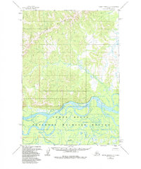
1952 Map of Russian Mission C-3
USGS Topo · Published 1989About this map
The Kuskokwim River serves as the dominant geographic anchor of this 1952 landscape, winding through a complex network of wetlands and sloughs. This portion of the Yukon Delta National Wildlife Refuge showcases the intricate relationship between the river and its southern tributary, Discovery Creek. The terrain transitions sharply from the low-lying river plains to the north, where the Portage Mountains provide significant elevation contrast. Evidence of seasonal passage is visible via the Winter Trail, which parallels the northern bank of the Kuskokwim. Sparse human markers, including a lone Cabin and the survey point VABM Spruce 722, highlight the isolation of this region during the mid-twentieth century, as mapped from aerial photography taken just after the war.
Find a feature on this map
8 named features on this map. Tap any name to fly to it.
Don’t see what you’re looking for? This feature index may not catch every label — zoom into the map to look around manually.
Map Details
Editions of this 1952 Russian Mission C-3 Map
3 editions found
Other maps of this area

1947 · Russian Mission
USGS Topo · 1:250,000

1950 · Russian Mission
USGS Topo · 1:250,000

1952 · Russian Mission D-2
USGS Topo · 1:63,360

1952 · Russian Mission D-3
USGS Topo · 1:63,360

1952 · Russian Mission C-3
USGS Topo · 1:63,360

1952 · Russian Mission C-2
USGS Topo · 1:63,360

1952 · Russian Mission D-4
USGS Topo · 1:63,360

1952 · Russian Mission B-2
USGS Topo · 1:63,360

1952 · Russian Mission B-3
USGS Topo · 1:63,360

1954 · Russian Mission C-4
USGS Topo · 1:63,360