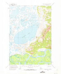
1954 Map of Russian Mission C-4
USGS Topo · Published 1973About this map
Kalskag and Lower Kalskag anchor this mid-century survey, situated along a prominent bend of the Kuskokwim River. The landscape is defined by the transition from the river lowlands to the elevated Portage Mountains in the east. This region serves as a critical traditional transit corridor, evidenced by the Yukon-Kuskokwim Portage and Paimiut Portage routes that cut through the terrain. To the west, large water bodies like Arhymot Lake and Kukaklik Lake dominate the tundra, interconnected by a network of seasonal routes including a Winter Trail. The mapping, based on 1952 aerial photography and field-annotated in 1954, captures the infrastructure of the era, such as the local Landing Strip and small drainages like Mud Creek and Crooked Creek.
Find a feature on this map
14 named features on this map. Tap any name to fly to it.
Don’t see what you’re looking for? This feature index may not catch every label — zoom into the map to look around manually.
Map Details
Editions of this 1954 Russian Mission C-4 Map
2 editions found
Other maps of this area

1947 · Russian Mission
USGS Topo · 1:250,000

1950 · Russian Mission
USGS Topo · 1:250,000

1952 · Russian Mission D-3
USGS Topo · 1:63,360

1952 · Russian Mission C-3
USGS Topo · 1:63,360

1952 · Russian Mission D-4
USGS Topo · 1:63,360

1952 · Russian Mission C-5
USGS Topo · 1:63,360
1952 · Russian Mission D-5
USGS Topo · 1:63,360

1952 · Russian Mission B-3
USGS Topo · 1:63,360

1954 · Russian Mission B-5
USGS Topo · 1:63,360

1954 · Russian Mission C-4
USGS Topo · 1:63,360