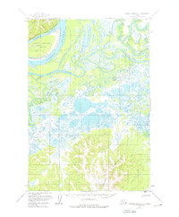
1952 Map of Russian Mission D-3
USGS Topo · Published 1976About this map
Yukon River waters dominate the northwest corner of this mid-century topographic study, defining a landscape shaped by shifting channels and braided waterways. The river bends around the expansive Great Paimiut Island, while a complex network of seasonal channels including Summer Slough, Paimiut Slough, and Twelvemile Slough weave through the surrounding wetlands. This environment is one of extreme contrast, where the low-lying basin, filled with unnamed lakes and marshes, meets the rising elevations of the Paimiut Hills and Portage Mountains. Distinctive landmarks like Tabernacle Mtn provide vertical relief in an area otherwise characterized by its intricate drainage patterns. The map documents the region's natural state before late-20th-century shifts, illustrating the precise relationship between the high ground and the saturated river plains.
Find a feature on this map
11 named features on this map. Tap any name to fly to it.
Don’t see what you’re looking for? This feature index may not catch every label — zoom into the map to look around manually.
Map Details
Editions of this 1952 Russian Mission D-3 Map
2 editions found
Other maps of this area

1947 · Russian Mission
USGS Topo · 1:250,000

1950 · Russian Mission
USGS Topo · 1:250,000

1951 · Holy Cross
USGS Topo · 1:250,000

1952 · Holy Cross A-2
USGS Topo · 1:63,360

1952 · Holy Cross A-3
USGS Topo · 1:63,360

1952 · Russian Mission D-2
USGS Topo · 1:63,360

1952 · Holy Cross
USGS Topo · 1:250,000

1952 · Russian Mission D-3
USGS Topo · 1:63,360

1952 · Russian Mission C-3
USGS Topo · 1:63,360

1952 · Russian Mission C-2
USGS Topo · 1:63,360