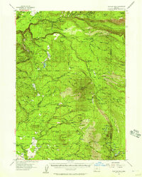
1955 Map of Rustler Peak
USGS Topo · Published 1961About this map
Prospect serves as the western gateway to this high-country landscape, where the Middle Fork Rogue River and South Fork Rogue River carve through the timbered terrain. The mid-1950s infrastructure of the region is well-defined, featuring the Copco Powerhouse and several remote outposts like the Imnaha Guard Sta and Lodgepole Guard Sta. The map reveals a network of working ranches and homesteads, including Mill-Mar Ranch, Thomson Ranch, and Rancheria Ranch, which are connected by historic routes like the Old Military Road.
Find a feature on this map
125 named features on this map. Tap any name to fly to it.
Don’t see what you’re looking for? This feature index may not catch every label — zoom into the map to look around manually.
Map Details
Editions of this 1955 Rustler Peak Map
3 editions found
Other maps of this area

1891 · Ashland
USGS Topo · 1:250,000

1893 · Ashland
USGS Topo · 1:250,000

1897 · Ashland
USGS Topo · 1:250,000

1938 · Medford
USGS Topo · 1:125,000

1944 · Abbott Butte
USGS Topo · 1:62,500

1947 · Abbott Butte
USGS Topo · 1:62,500

1954 · Butte Falls
USGS Topo · 1:62,500

1954 · Lakecreek
USGS Topo · 1:62,500

1955 · Lake O' Woods
USGS Topo · 1:62,500

1955 · Rustler Peak
USGS Topo · 1:62,500