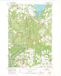
1953 Map of Saginaw
USGS Topo · Published 1971About this map
Fond Du Lac Indian Reservation land occupies the southwestern portion of this landscape, where the St Louis River carves a dramatic bend around Pine Island. The era's heavy industrial and transit character is evident in the dense network of railroads serving the region, including the Duluth Missabe and Iron Range and the Duluth Northeastern. These lines intersect near the settlements of Saginaw and Grand Lake (Saginaw PO), which served as local hubs for the surrounding rural townships.
Find a feature on this map
28 named features on this map. Tap any name to fly to it.
Don’t see what you’re looking for? This feature index may not catch every label — zoom into the map to look around manually.
Map Details
Editions of this 1953 Saginaw Map
4 editions found
Other maps of this area

1953 · Twig
USGS Topo · 1:24,000

1953 · Saginaw
USGS Topo · 1:24,000

1953 · Adolph
USGS Topo · 1:24,000

1953 · Alborn
USGS Topo · 1:24,000

1953 · Brookston
USGS Topo · 1:24,000

1953 · Independence
USGS Topo · 1:24,000

1953 · Duluth
USGS Topo · 1:250,000

1954 · Cloquet
USGS Topo · 1:24,000

1954 · Esko
USGS Topo · 1:24,000

1954 · Iverson
USGS Topo · 1:24,000