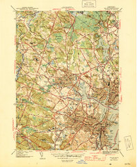
1944 Map of Salem
USGS Topo · Published 1944About this map
The shoreline of Salem Harbor and Beverly Harbor reveals a bustling coastal economy in the years during World War II. The landscape is heavily marked by institutional and public infrastructure, including the Danvers State Hospital, the County Sanatorium, and the State Teachers College. Local heritage is anchored by a significant concentration of burial grounds, ranging from the colonial-era Old Settlers Burying Ground and Bradstreet & Porter Burying Ground to the specialized Sons of Jacob Cem and Bnai Brith Cem.
Find a feature on this map
161 named features on this map. Tap any name to fly to it.
Don’t see what you’re looking for? This feature index may not catch every label — zoom into the map to look around manually.
Map Details
Editions of this 1944 Salem Map
3 editions found
Other maps of this area

1886 · Lawrence
USGS Topo · 1:62,500

1888 · Lawrence
USGS Topo · 1:62,500

1888 · Salem
USGS Topo · 1:62,500

1892 · Boston Bay
USGS Topo · 1:62,500

1893 · Salem
USGS Topo · 1:62,500

1893 · Boston
USGS Topo · 1:62,500

1893 · Lawrence
USGS Topo · 1:62,500

1903 · Boston
USGS Topo · 1:62,500

1903 · Boston Bay
USGS Topo · 1:62,500

1917 · Salem
USGS Topo · 1:62,500