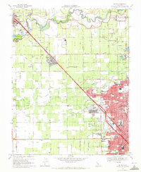
1969 Map of Salida
USGS Topo · Published 1972About this map
The Stanislaus River defines the northern reaches of this landscape, separating the orchard-rich lands of Ripon from the expanding northern neighborhoods of Modesto. In the late 1960s, the region was a complex mosaic of agriculture and institutional development. The massive footprint of the Modesto State Hospital stands as a prominent landmark near the center of the sheet, while the Hetch Hetchy Aqueduct cuts a diagonal path across the valley floor.
Find a feature on this map
62 named features on this map. Tap any name to fly to it.
Don’t see what you’re looking for? This feature index may not catch every label — zoom into the map to look around manually.
Map Details
Editions of this 1969 Salida Map
4 editions found
Other maps of this area

1914 · Manteca
USGS Topo · 1:31,680

1914 · Avena
USGS Topo · 1:31,680

1915 · Ripon
USGS Topo · 1:31,680

1915 · Westport
USGS Topo · 1:31,680

1915 · Westley
USGS Topo · 1:31,680

1915 · Salida
USGS Topo · 1:31,680

1915 · Thalheim
USGS Topo · 1:31,680

1916 · Riverbank
USGS Topo · 1:31,680

1916 · Ceres
USGS Topo · 1:31,680

1939 · Modesto East
USGS Topo · 1:62,500