
1954 Map of Salter Creek
USGS Topo · Published 1970About this map
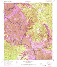
The Sabine River forms the central spine of this borderland survey, marking the jagged boundary between Texas and Louisiana. This edition documents a landscape in flux, specifically noting the development of the Toledo Bend Reservoir as it began to reshape the river valley. In the Louisiana territory, the La Nana Grant and the settlement of Shady Grove sit amidst a complex network of waterways like Salter Creek and Town Branch. Along the Texas side, the Sabine National Forest preserves a denser wooded character, reaching down to the river near Goodlow Bluff. For genealogists, the map preserves the locations of local landmarks such as Mullet Cemetery, Beulah Church, and Harpers Chapel, alongside the winding course of Palo Gaucho Bayou and Patroon Bayou before the rising waters of the reservoir fully transformed the riparian ecosystem.
Find a feature on this map
30 named features on this map. Tap any name to fly to it.
Don’t see what you’re looking for? This feature index may not catch every label — zoom into the map to look around manually.
Map Details
Editions of this 1954 Salter Creek Map
2 editions found
Other maps of this area

1941 · Zwolle
USGS Topo · 1:62,500

1944 · Negreet
USGS Topo · 1:62,500

1944 · Patroon
USGS Topo · 1:62,500

1944 · Zwolle
USGS Topo · 1:62,500

1953 · Alexandria
USGS Topo · 1:250,000

1954 · Toro
USGS Topo · 1:24,000

1954 · Columbus
USGS Topo · 1:24,000
1954 · Negreet
USGS Topo · 1:24,000

1954 · Negreet
USGS Topo · 1:62,500

1955 · Alexandria
USGS Topo · 1:250,000