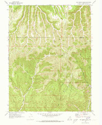
1970 Map of San Arroyo Ridge
USGS Topo · Published 1973About this map
Industrial expansion in the high desert of Eastern Utah is recorded here through a dense network of energy infrastructure. The plateau is dominated by the San Arroyo Gas Field, East Canyon Gas Field, and Overlook Gas Field, where numerous Gas Wells and pipelines snake through the complex topography. At the heart of these operations sits the San Arroyo Camp, a lonely settlement serving the gas workers near the headwaters of San Arroyo Creek.
Find a feature on this map
29 named features on this map. Tap any name to fly to it.
Don’t see what you’re looking for? This feature index may not catch every label — zoom into the map to look around manually.
Map Details
Editions of this 1970 San Arroyo Ridge Map
2 editions found
Other maps of this area

1885 · East Tavaputs
USGS Topo · 1:250,000

1956 · Grand Junction
USGS Topo · 1:250,000

1959 · Grand Junction
USGS Topo · 1:250,000

1960 · Grand Junction
USGS Topo · 1:250,000

1962 · Grand Junction
USGS Topo · 1:250,000

1964 · Grand Junction
USGS Topo · 1:250,000

1965 · Grand Junction
USGS Topo · 1:250,000

1966 · Seep Canyon
USGS Topo · 1:24,000

1966 · Tom Patterson Canyon
USGS Topo · 1:24,000
1966 · Rat Hole Ridge
USGS Topo · 1:24,000