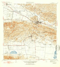
1941 Map of San German
USGS Topo · Published 1952About this map
The town of San Germán sits as the central hub of this mid-century landscape, divided into the Pueblo Central, Pueblo Occidental, and Pueblo Oriental districts. The American Railroad Linea Porto Rico cuts a distinctive path through the valley, supporting a network of sugarcane infrastructure and rural estates. Numerous agricultural haciendas, including Hacienda Rosario, Hacienda Luisa, and Hacienda Beatriz Soledad, define the land use patterns between the Río Guanajibo and the southern marshlands of Laguna Cartagena. Further south, the settlement of Lajas is linked by the rail line, serving the surrounding barrios. The presence of the Instituto Politecnico and several specialized religious sites, such as the Capilla de San José de la Montaña and Iglesia Presbiteriana, illustrate the established civic and cultural character of this southwestern region of Puerto Rico.
Find a feature on this map
93 named features on this map. Tap any name to fly to it.
Don’t see what you’re looking for? This feature index may not catch every label — zoom into the map to look around manually.
Map Details
Editions of this 1941 San German Map
5 editions found
Other maps of this area

1935 · Puerto Real
USGS Topo · 1:25,000

1937 · San German
USGS Topo · 1:25,000

1937 · Sabana Grande
USGS Topo · 1:25,000

1937 · Puerto Real
USGS Topo · 1:25,000

1938 · Guanica
USGS Topo · 1:30,000

1938 · Parguera
USGS Topo · 1:30,000

1938 · Cabo Rojo
USGS Topo · 1:30,000

1939 · Mayaguez
USGS Topo · 1:30,000

1941 · San German
USGS Topo · 1:30,000

1941 · Puerto Real
USGS Topo · 1:30,000