Loading...
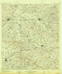
Loading map...1911 Map of San Marcos
USGS Topo · Published 1931About this map
The San Marcos River and Guadalupe River dominate this Central Texas landscape, carving through a region defined by dense rural school districts and burgeoning railroad junctions. Early twentieth-century settlement patterns are visible through the concentration of dozens of local educational sites, such as Tieman School Junior, McCutcheon School, and McCullough School, which served the farming families of Hays, Caldwell, and Guadalupe counties.
Find a feature on this map
100 named features on this map. Tap any name to fly to it.
Don’t see what you’re looking for? This feature index may not catch every label — zoom into the map to look around manually.
Map Details
Date Portrayed1911
Date Published1931
PublisherU.S. Geological Survey
Map TypeTopographic
Scale1:125,000
Physical Dimensions16.5 x 19.7 inches
Editions of this 1911 San Marcos Map
2 editions found

Historical Maps of San Marcos Through Time

Featured Locations
Source Details
SourceU.S. Geological Survey
CopyrightPublic Domain