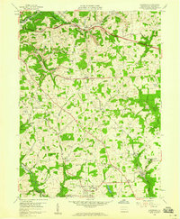
1958 Map of Saxonburg
USGS Topo · Published 1959About this map
Saxonburg anchors the southern portion of this mid-century landscape, surrounded by a dense network of crossroads hamlets and small parochial centers. The terrain is defined by the winding paths of the Baltimore and Ohio and the Bessemer and Lake Erie railroads, which facilitated local industrial activity like the numerous strip mines and gas wells scattered throughout Summit and Jefferson townships.
Find a feature on this map
52 named features on this map. Tap any name to fly to it.
Don’t see what you’re looking for? This feature index may not catch every label — zoom into the map to look around manually.
Map Details
Editions of this 1958 Saxonburg Map
4 editions found
Other maps of this area

1900 · Kittanning
USGS Topo · 1:62,500

1902 · Kittanning
USGS Topo · 1:62,500

1907 · Freeport
USGS Topo · 1:62,500

1908 · New Kensington
USGS Topo · 1:62,500

1909 · Freeport
USGS Topo · 1:62,500

1909 · Butler
USGS Topo · 1:62,500

1910 · New Kensington
USGS Topo · 1:62,500

1911 · Butler
USGS Topo · 1:62,500

1950 · Valencia
USGS Topo · 1:24,000

1953 · Pittsburgh
USGS Topo · 1:250,000