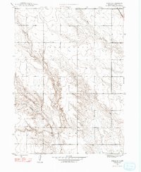
1948 Map of School No. 7
USGS Topo · Published 1993About this map
School No 7 and its counterparts stand as lonely markers of rural education across the high plains of Box Butte County in the mid-1940s. This survey, conducted by the Geological Survey and the Bureau of Reclamation, details a landscape defined by seasonal watercourses and expansive land divisions like Nonpareil and Wright. The drainage of the North Branch and South Branch cuts through the terrain, leading toward Berea Creek and the prominent North Point Rocks. The mapping reflects a period of systematic land management and agricultural planning, where the placement of School No 17 and School No 58 highlights the distribution of the farming population before the consolidation of rural school districts. The intricate contouring reveals the subtle draws and ridges that dictated the placement of homesteads and early roadways in this corner of Nebraska.
Find a feature on this map
12 named features on this map. Tap any name to fly to it.
Don’t see what you’re looking for? This feature index may not catch every label — zoom into the map to look around manually.
Map Details
Editions of this 1948 School No. 7 Map
4 editions found
Other maps of this area

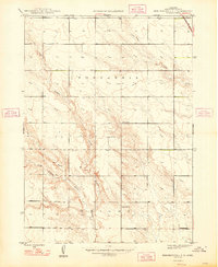
1946 · Nonpareil
USGS Topo · 1:24,000

1947 · Bronco Lake
USGS Topo · 1:24,000

1948 · Hemingford
USGS Topo · 1:24,000

1948 · Hemingford 4 SW
USGS Topo · 1:24,000

1948 · Hemingford 4 SE
USGS Topo · 1:24,000

1948 · Berea Creek West
USGS Topo · 1:24,000

1948 · Hemingford 4 NE
USGS Topo · 1:24,000

1948 · Hemingford 4 NW
USGS Topo · 1:24,000

1948 · Nonpareil
USGS Topo · 1:24,000

1949 · Box Butte SW
USGS Topo · 1:24,000