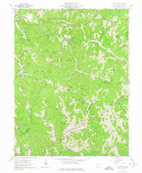
1961 Map of Schultz
USGS Topo · Published 1974About this map
Goose Creek winds through the southeastern corner of this terrain, marking a landscape defined by sharp ridges and deep runs in the early 1960s. The settlement of Schultz sits along Schultz Run, while Calcutta is found to the north near Calcutta Cem. This area is a patchwork of small upland communities and rural infrastructure, evidenced by the numerous Gas Well sites and utility corridors labeled Pipeline and Telephone that cross the hills. Religious life is well-documented through several country churches, including Ingram Ch, Glendale Ch, and Mt Zion Ch, which often served as the focal points for these ridge-top and valley-floor neighborhoods. The map even records specific industrial landmarks like a Pumping Station near Sharps Run, providing a detailed look at the resource extraction and rural settlement patterns in this part of West Virginia before modern consolidation.
Find a feature on this map
56 named features on this map. Tap any name to fly to it.
Don’t see what you’re looking for? This feature index may not catch every label — zoom into the map to look around manually.
Map Details
Editions of this 1961 Schultz Map
3 editions found
Other maps of this area

1904 · Marietta
USGS Topo · 1:62,500

1906 · Saint Marys
USGS Topo · 1:62,500

1906 · Elizabeth
USGS Topo · 1:62,500

1907 · Harrisville
USGS Topo · 1:62,500

1924 · St Marys
USGS Topo · 1:62,500

1924 · Harrisville
USGS Topo · 1:62,500

1924 · Marietta
USGS Topo · 1:62,500

1924 · Elizabeth
USGS Topo · 1:62,500

1926 · Elizabeth
USGS Topo · 1:62,500

1926 · Harrisville
USGS Topo · 1:62,500