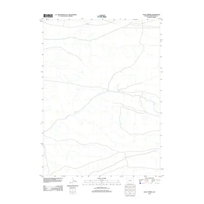
2012 Map of Scott Spring
USGS Topo · Published 2012About this map
Scott Spring is the focal point of this arid landscape in Sweetwater County, Wyoming. The terrain is defined by a dendritic network of seasonal drainages that navigate the undulating topography of the high desert. Human impact on the land is sparse, primarily represented by 14 Mile Rd which traverses the northern reaches of the quadrangle. This 2012 survey by the U.S. Geological Survey provides a precise view of the water sources and access routes essential for navigating this open range. The lack of named settlements reflects the enduring character of this region as a place for grazing and natural resource management rather than permanent habitation.
Find a feature on this map
2 named features on this map. Tap any name to fly to it.
Don’t see what you’re looking for? This feature index may not catch every label — zoom into the map to look around manually.
Map Details
Editions of this 2012 Scott Spring Map
This is the sole edition of this map. No revisions or reprints were ever made.
Other maps of this area

1954 · Rock Springs
USGS Topo · 1:250,000

1958 · Rock Springs
USGS Topo · 1:250,000

1961 · Scott Spring
USGS Topo · 1:24,000

1961 · Peru
USGS Topo · 1:24,000

1961 · Pilot Butte
USGS Topo · 1:24,000

1961 · Austin Ranch
USGS Topo · 1:24,000

1961 · Kanda
USGS Topo · 1:24,000

1961 · Green River
USGS Topo · 1:24,000

1962 · Rock Springs
USGS Topo · 1:250,000
1963 · Chrisman Ranch
USGS Topo · 1:24,000