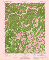
1952 Map of Scranton
USGS Topo · Published 1967About this map
Frenchburg serves as a primary hub in this pocket of the Cumberland Plateau during the early 1950s, where winding ridges and deep hollows dictate the layout of small farming and timber communities. The landscape is defined by the sharp relief of Kendrick Ridge and Ponder Ridge, with settlements like Scranton and Mariba connected by a network of winding roads including Us 460. This survey documents a rural economy still very much tied to the land and its resources, evidenced by scattered Oil Wells, a Quarry, and the broad reaches of the Daniel Boone National Forest. Local life centers around numerous remote schools and churches, such as Kendrick Ridge Sch and Bethel Ch, and family landmarks like the Ingram Cem and Staton Cem that anchor the genealogies of Menifee County. The McCausey Ridge Lookout Tower stands as a prominent landmark overlooking the labyrinthine drainages of Beaver Creek and Brier Creek.
Find a feature on this map
65 named features on this map. Tap any name to fly to it.
Don’t see what you’re looking for? This feature index may not catch every label — zoom into the map to look around manually.
Map Details
Editions of this 1952 Scranton Map
2 editions found

Other maps of this area

1889 · Salyersville
USGS Topo · 1:125,000

1891 · Salyersville
USGS Topo · 1:125,000

1892 · Beattyville
USGS Topo · 1:125,000

1899 · Salyersville
USGS Topo · 1:125,000

1929 · Morehead
USGS Topo · 1:48,000

1929 · Salt Lick
USGS Topo · 1:62,500

1934 · Salt Lick
USGS Topo · 1:62,500

1935 · Morehead
USGS Topo · 1:62,500

1951 · Ezel
USGS Topo · 1:24,000

1951 · Hazel Green
USGS Topo · 1:24,000