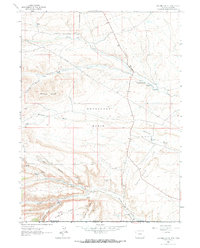
1963 Map of Scrivner Butte
USGS Topo · Published 1966About this map
The high desert landscape straddling the Wyoming and Colorado border is defined here by a network of isolated homesteads and emerging energy extraction. Settled along the drainage of Vermillion Creek and its tributaries, working ranch lands like the Rife Ranch, Scofield Ranch, and Graham Ranch anchor the remote terrain. The survey captures the mid-century industrial expansion into the Horseshoe Basin, where a growing Gas Field and the presence of the Canyon Creek Mine indicate a shift from traditional livestock operations toward resource development. Local geography is sharply articulated through named features such as Scrivner Butte and the deep incisions of Owl Canyon and Scrivner Canyon. Numerous water sources, including McKnight Spring and Two Bar Spring, underscore the critical importance of water rights in this arid environment, while a prominent Pipeline snakes across the basin floor, linking the remote extraction sites to distant markets.
Find a feature on this map
42 named features on this map. Tap any name to fly to it.
Don’t see what you’re looking for? This feature index may not catch every label — zoom into the map to look around manually.
Map Details
Editions of this 1963 Scrivner Butte Map
2 editions found
Other maps of this area

1954 · Vernal
USGS Topo · 1:250,000

1954 · Rock Springs
USGS Topo · 1:250,000

1958 · Vernal
USGS Topo · 1:250,000

1958 · Rock Springs
USGS Topo · 1:250,000

1960 · Vernal
USGS Topo · 1:250,000

1962 · Rock Springs
USGS Topo · 1:250,000

1963 · Four J Rim
USGS Topo · 1:24,000
1963 · Potter Mountain
USGS Topo · 1:24,000

1963 · Erickson-Kent Ranch
USGS Topo · 1:24,000

1963 · Scrivner Butte
USGS Topo · 1:24,000