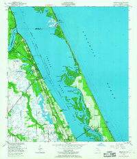
1949 Map of Sebastian
USGS Topo · Published 1967About this map
Pelican Island Bird Sanctuary anchors this 1949 study of the Florida coastline, representing a critical wildlife haven amid the developing barrier islands. The landscape is defined by the broad expanse of the Indian River and the Intracoastal Waterway, which separate mainland settlements like Roseland and Sebastian from the Atlantic shore. Transportation and infrastructure are central to the area's mid-century character, with the Florida East Coast Railway and the Florida Central and West Coast Railroad running parallel to the coast. These rail lines supported small communities such as Cummings and Wabasso, while the Roseland Airport and the Airway Beacon reflect the era's growing aviation needs. The map captures an intricate network of coastal hydrology, from the Sebastian Inlet to the many named islands and holes like Collins Hole and Preachers Hole, showing the region just before the significant modern residential expansion.
Find a feature on this map
54 named features on this map. Tap any name to fly to it.
Don’t see what you’re looking for? This feature index may not catch every label — zoom into the map to look around manually.
Map Details
Editions of this 1949 Sebastian Map
5 editions found
Other maps of this area

1948 · Riomar
USGS Topo · 1:24,000

1949 · Fellsmere
USGS Topo · 1:24,000

1949 · Sebastian NW
USGS Topo · 1:24,000

1949 · Vero Beach
USGS Topo · 1:24,000

1949 · Sebastian
USGS Topo · 1:24,000

1949 · Grant
USGS Topo · 1:24,000

1950 · Riomar
USGS Topo · 1:24,000

1950 · Vero Beach
USGS Topo · 1:24,000

1951 · Sebastian NW
USGS Topo · 1:24,000

1951 · Fellsmere
USGS Topo · 1:24,000